The Excavation Seasons
- Results of the 2010 excavations (Season 1)
- Results of the 2011 excavations (Season 2)
- Results of the 2012 excavations (Season 3)
- Results of the 2013 excavations (Season 4)
- Results of the 2014 excavations (Season 5)
- Results of the 2015 excavations (Season 6)
- Plans for the 2016 excavations (Season 7)
Results of the 2010 excavations (Season 1)
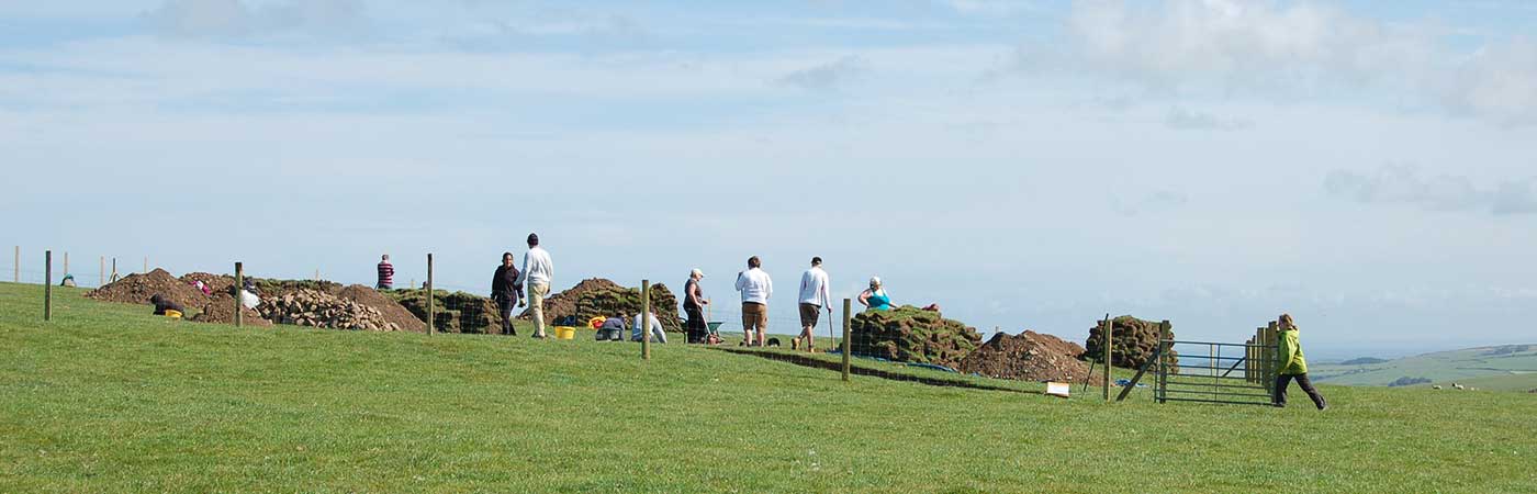
The first season of excavations at Meillionydd confirmed the presence of earth and stone banks and revealed that the banks were accompanied by quarry hollows. Within the trenches which investigated slices through the interior of the enclosure, there was evidence for a lengthy sequence of occupation which probably spans most of the first millennium BC, indicated by multiple sequences of timber and stone roundhouses which were built on the same locations.
Trench 1
Trench 1 examined a narrow slot through the inner bank and ditch/quarry hollow in the south-eastern part of the enclosure. The sequence of roundhouses at the north-western end of the trench consisted of a complex of postholes and gullies, indicating one or two timber structures, which were followed by the construction of a stone-walled roundhouse, c. 5m in diameter. The inner bank, situated to the east, was partially set within a shallow linear trench which contained an alignment of deliberately placed large boulders. The sequence at the south-east end is represented by a series of boundary ditches. The settlement was first enclosed by a narrow U-shaped ditch. This was later truncated by the creation of a shallow, wide flat-bottomed quarry hollow, located immediately in front of the outer bank in Trench 2 (and presumably associated with its construction). The rubble fills of the quarry hollow suggest that it was deliberately back-filled, possibly during the abandonment of the site when the roundhouses and bank structures were destroyed.
Trench 2
Trench 2 investigated a slot through the outer bank on the south-eastern side of the enclosure, near the entranceway. The bank was constructed from a simple dump of earth and stone, which contained some burnt stones, and inner facing stones were identified. This structure had been badly disturbed and truncated. Some interesting features were identified underneath and just in front of the bank in the south-western corner of the trench – these features were exposed but left unexcavated. They consist of three postholes and a curvilinear wall foundation, which may either be associated with the bank or possibly represent the existence of pre-bank occupation structures.
Trench 3
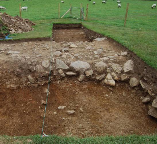
Trench 3 was positioned over an area of magnetic enhancement in the eastern part of the interior. A sequence of at least two timber roundhouses and possibly three stone roundhouses were identified within the area, alongside the disturbed remains of the inner bank. An early timber roundhouse is represented by an arc of postholes which appear to have defined a circular building which is associated with a central hearth. At least one, or possibly two, stone roundhouses were then constructed on the same spot, and situated within a hollow identified along the north-western side of the trench, which created a flat platform or terrace. The latest stone roundhouse was c. 8m in diameter, with an entrance to the southeast. The building was created from a thick stone-faced wall with an earth or turf core. Within the roundhouse, a large stone-lined pit was identified, and two stone spindlewhorls were also recovered from disturbed floor layers.
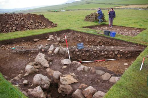
The stone roundhouse wall in Trench 3
The stone roundhouse wall in Trench 3, which sealed a hearth pit associated with an earlier post-built roundhouse.
Results of the 2011 excavations (Season 2)
In the excavation season in 2011, we reopened and extended the 2010 trial trenches on the south-eastern side of the enclosure, near to the entrance-way, in order to characterise different areas. Trench 1 originally looked at a roundhouse, the inner bank and part of a quarry hollow – it was extended in 2011 to the east and the west so that a full section through the outer and inner bank and the inner roundhouse could be explored. Trench 2 originally examined the outer bank and this was extended in 2011 to explore more of the bank structure and the quarry hollow. Trench 3 examined part of the inner bank and roundhouses.
The stone roundhouse wall set into the outer bank next to the entranceway, Trench 2.
The excavations demonstrated that the outer bank is constructed from simple dumps of earth and stone, faced roughly with stones, and associated with quarry scoops. A wide quarry hollow, c. 6m wide, is located in front of the outer bank. It truncated an earlier ditch which is visible on the geophysics and represents an earlier phase of boundary. The quarry hollow was also the focus for occupation activity in a later phase of the settlement. Rather unexpectedly, the extension to trench 2 revealed that the bank partially incorporated a later stone roundhouse. This building, being attached to the outer bank and next to the enclosure entranceway, may have played an important role on the settlement.
The inner bank is very different. This was badly preserved and only the foundation stones survived – consisting of a linear arrangement of boulders set within a shallow foundation trench and located immediately behind a roundhouse platform. The stone infills within the quarry hollow demonstrate that the banks were deliberately slighted during occupation or abandonment.
Timber and stone roundhouse phases were identified within the interior. The roundhouse platform in trench 1 west extension was set within a shallow terrace scoop, and the floor is characterised by a number of postholes and large pits. The curving wall slot of a plank built roundhouse terminated within a large pit with packing stones, which is probably the door-post of an east-facing entrance porch. Part of a curvilinear stone wall was located next to the wall slot, which can be interpreted as the remains of a later stone roundhouse which was set into the body of the bank. On abandonment, the roundhouse platform was deliberately infilled with compact rubble layers which appear to partly derive from the slighting of the adjacent bank structure. This is a substantial packing, c. 50cm thick, which is rich in heat-affected stone and it is certainly a deliberate infill.
The outer bank, showing the rough inner facing stones.
The hut platform in Trench 1 west extension, showing the pits before excavation and the curvilinear wall gully, with upright packing stones in situ (the stretch of the gully in the foreground was excavated in 2010). The stone infill of the roundhouse is clearly visible in the section.
The hut platform and the features in the floor of the roundhouse in Trench 1 west extension.
In trench 3, a number of roundhouses were identified. The early occupation phases are represented by small pits and gullies which are difficult to reconstruct. A post-built timber roundhouse, c. 12m in diameter, was clearly identified and this contained a central hearth pit. This showed evidence for being rebuilt at least once and a large double posthole on the southeast indicates the location of an entrance porch. The central hearth is securely placed in this phase as it was truncated and sealed by a later stone roundhouse wall. A date of 753–410 cal. BC (2 sigma; GU26311) on charred twigs from the basal fill of the hearth confirms an earlier Iron Age date for the building. Following its abandonment, a substantial cut for a terrace was created and within this there is tentative evidence for two roundhouses. The second phase was well defined. This stone roundhouse has a diameter of c. 9m, with an entrance to the SW. Where the stone-faced wall was positioned within the terrace cut, it stood to a height of 0.75m with a thickness of c. 1.5m. The house floor was cut by pits which include a stone-lined storage pit and a series of working hollows. One of the final working hollows produced a date of 384–203 cal. BC (2 sigma; GU26312), which would place this building in the Middle Iron Age. The building had also been deliberately infilled with stone rubble and the deposits produced three spindlewhorls, two of which were unfinished. These deposits may well indicate the presence of elaborate closing rites which took place on the settlement during its abandonment.
The features associated with the timber roundhouse in Trench 3.
The Middle Iron Age stone roundhouse in Trench 3.
Results of the 2012 excavations (Season 3)
In July 2012, we opened up a large trench, which was c. 12m by 24m, which was an extension of the previous trenches 1 and 2. Our main aims were to uncover all of a stone roundhouse that we partially exposedthe year before. This building is built into a wide quarry hollow which is located in front of the outer bank. The quarry hollow was used to extract material to build the bank, and so we did not expect to find a house here. It is located next to the entrance through the outer bank and so it might have had a special role on the settlement. We excavated all of the rubble and soil that filled the house after it was abandoned, and the walls on all sides have been uncovered. The features in the house floor were not excavated and had been saved for the 2013 excavations. The house visibly sat on top of the earlier truncated ditched enclosure. We found some stone objects, such as grinders and hammers, as well as a lead spindlewhorl, and a sherd of later Iron Age pottery. Pottery and metalwork are very scarce in the Iron Age in northwest Wales, where the soils are acidic and the communities are aceramic, and so these finds are exciting.
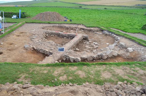
The house set into the outer bank and quarry hollow.
We also excavated the in-turned entranceway through the inner bank, as well as a track-way which leads through the entrance to the settlement. The track is roughly cobbled and it provided a good hard surface for the traffic of animals, people and carts into the enclosure. The inner face of the bank in the entranceway was made up of large blocks of stone, which would have looked very 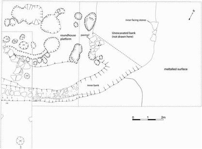 impressive at the time, although the boundary is very badly preserved today. Underneath one of the facing stones was another lead spindlewhorl.
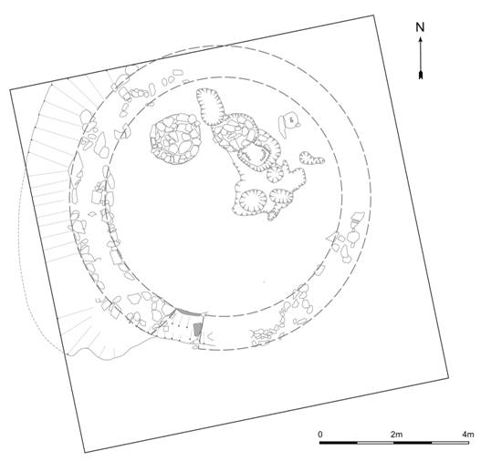
Plan of Trench 1 and Trench 1 west extension, showing the roundhouse platform, the curving inner bank, and the metalled surface through the entranceway. Not all the deposits have been digitised on this plan but it gives an idea of the nature of the inner bank and adjacent roundhouse platform.
Results of the 2013 excavations (Season 4)
During the 2013 season we re-opened our large trench from the previous season to expand our knowledge of the entrance and enclosures and to complete the total excavation of the stone round house situated between inner and outer bank next to the entrance passage.
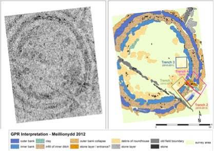
GPR Interpretation of the double ringwork enclosure of Meillionydd (by ZAMG) showing former and future trenches (image: R. Karl)
In trench 1, we had already located the entrance through the inner enclosure, which was characterised by an inturn of the bank into a relatively narrow (c. 3 meters wide) entrance passage, in 2012. The entrance passage had a densely packed layer of cobbling consisting of small pebbles, which probably was the surface of the later phase entrance. While examining this layer further in 2013, we were able to expose a second layer of cobbling consisting of small stones underneath it, which turned out to be the entrance passage into the earlier timber enclosure, with the substantial posts of a rectangular timber gatehouse located near the north-eastern corner of trench 1 and the north-western corner of trench 2.
Excavation staff standing in the postholes of the early timber enclosure in trench 1 and trench 2 (combined in 2013). Two staff standing next to each other mark a double posthole (photo: R. Karl).
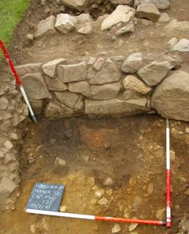
In trench 2 we finished the excavations on the stone roundhouse which had been set into the quarry hollow located immediately inside the outer bank of the site. In its floor, it had a well-preserved ring of timber posts to support a roof, a sizable drainage gully, and a large ash pit near the centre, probably associated with a fireplace or hearth. The house also was set on top of the early timber phase u-shaped ditch, which terminated in this trench inside the roundhouse floor. In the ditch terminus, we were able to identify a number of deposited Iron objects, although those were so badly corroded that in most cases, it was impossible to identify what items these had originally been. Near the northern end of trench 2, the cobbled road surface continued from where we had located it in the north-eastern corner of trench 1 towards the entrance into the outer enclosure, which lies just outside the area of trench 2. Underneath the bank, we were also able to identify a layer of cobbling, which indicates that in the earlier phase, there had been a cobbled yard outside the timber gatehouse, extending c. 10 meters from the gate and probably semi-circular in shape.
Trench 1 and 2 combined. Various features are visible. Liliac: early timber palisade and gatehouse. Light blue: u-shaped ditch associated with the timber palisade. Dark blue: timber roundhouse, probably contemporary with the timber palisade. Orange: early phase stone cobbling, forming a cobbled yard outside the timber gatehouse. Red: banks of the later phase, forming the double ringwork – note the inturning entrances. Yellow: cobbled surface of the later phase entrance passage. Brown: Stone roundhouse set into the inner bank near its entrance. Green: Stone roundhouse with timber postring and central ash-pit, built into quarry hollow and outer bank near the end of the occupation sequence of the site (photo: F. Ohl).
Results of the 2014 excavations (Season 5)
In 2014 we opened up two new trenches (trench 4 and 5) to further examine the cobbled road leading from the entrance through the outer bank to the inner entrance. While trench 4 was situated to the North East of previous trenches 1 and 2, trench 5 connected the new trench 4 with trench 3 from 2010, thereby creating a completely excavated area of c. 800m2.
Trench 4
Trench 4 investigated the entrance through the outer bank. Both bank terminals were clearly visible. However, in both cases only the bottom row of facing stones remained in situ. Nonetheless, the remaining layer made it possible to determine that the entrance passage was c. 1.8m wide. In contrast to the entrance through the inner enclosure, which was inturned and seems to have contained a substantial gatehouse, the entrance through the outer enclosure is a simple gap in the bank and did not contain a gatehouse. Rather, the few small postholes that were found associated with the outer entrance indicate that if at all, a very simple, insubstantial gate comparable to modern field gates, was present to shut the outer entrance.
The metalled road surface which had been discovered in previous years ran through the entrance of the outer bank and connected it with the inner bank entrance. The earlier phase of metalling seems to have been covered by the southern terminal of the outer bank and thus belongs to an earlier building phase, predating the construction of the outer bank.
Corresponding with our results from previous years the quarry hollow as well as the northern terminal of the U-shaped ditch and a linear alignment of post holes representing the wooden palisade of one of the earliest building phases were uncovered. At the bottom of the U-shaped ditch a heavily corroded hewing knife was found. Both the northern and southern terminal of the quarry hollow, which seems to have been created to extract material for the construction of the outer bank, had associated drainage gullies. The gully draining the northern terminal of the quarry hollow went out of the enclosure through the entrance passage, while the gully draining the southern terminal of the quarry hollow is the one identified in the roundhouse excavated in trench 2, which went under the southern bank terminal and also emptied into the entrance passage. The presence of drainage gullies in the entrance passage is closely comparable to observations made by Alcock at Castell Odo.
Trench 5
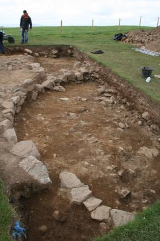
In Trench 5 badly damaged remains of the northern terminal of the inner bank as well as a sequence of roundhouses was discovered. One of these was the roundhouse which was first discovered along the southern side of Trench 3C in 2010. Again, much like in adjacent trench 3, the stratigraphic sequence of roundhouse construction in trench 5 is quite complex, with several timber phases preceding the construction of the inner bank. The inner bank, in turn, was later partially obliterated by the construction of several stone roundhouse phases.
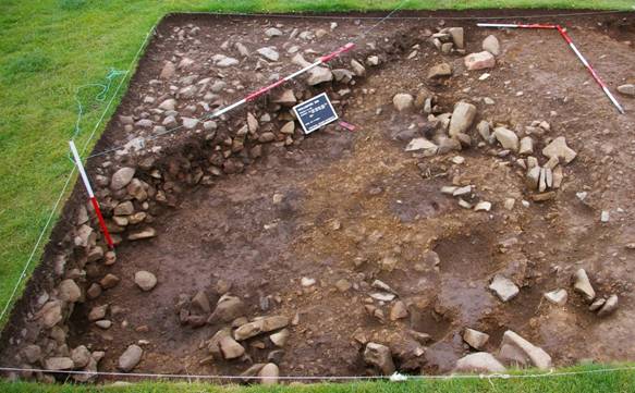
In the Western corner of the trench was an area covered with large stones, probably of the collapsed wall of the last roundhouse constructed in this spot. Underneath, a stone lined pit was found. While excavating the pit two blue glass beads were discovered. Next to the pit underneath the loosely infilled layer of stones, sea shells were uncovered. The shells, which seem to have been deposited in an organic bag, survived in the loosely infilled pockets where they were not completely surrounded by the highly acidic soils. Two further stone spindlewhorls were also discovered in this area of the trench, underneath the collapsed roundhouse wall above and next to the stone lined pit.
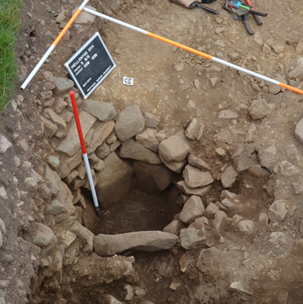
The stone lined pit in Trench 5.
Results of the 2015 excavations (Season 6)
Excavations in summer 2015 focussed on completing the work on the entrance area and starting examining the inside of the inner enclosure. At the end of season 6, c. 1100 m2 (c. 11%) of the Meillionydd double ringwork enclosure have been excavated. The 2015 excavations not only helped to clarify the shape of the inner entrance into the enclosure, but also to refine the phasing of the site.
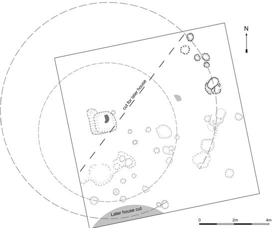
In total, the chronological sequence of 8 main phases could be determined, with some of the main phases consisting of several sub-phases. Of those, the first two (which can be further subdivided into 5 sub-phases whose chronological order could not be determined) are characterised by timber-built roundhouses; while in the last 6 phases, both roundhouse walls and the banks enclosing the site are built as drystone-faced earth walls. The latter construction method is still being used in the area to construct field boundary walls, including those surrounding the field in which the site is located.
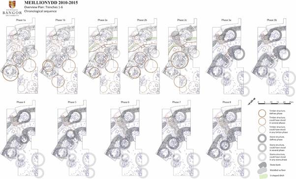
The building phases at Meillionydd (image: R. Karl).
The first main phase of occupation at Meillionydd was an open (unenclosed) settlement. Two separate sub-phases (1A and 1B) could be identified as belonging to this phase. At least one of the buildings of one of these sub-phases partially overlaps with a building of the other sub-phase, demonstrating that both cannot be contemporary with each other; although their chronological sequence could not be established. Also, one of these buildings overlaps with the timber palisade that defines the 2nd main phase of the occupation of the site, while the other would almost completely block up the gate leading through the palisade, making it impossible or very unlikely that they would have been contemporary with the timber-palisaded enclosure. This main phase also contains the largest buildings excavated on the site as of yet, with one partially excavated example having a diameter of c. 15 meters. This phase probably dates to the Late Bronze to Iron Age transition period.
The second main phase of occupation at Meillionydd was a timber-palisaded settlement. Three separate sub-phases (2A, 2B and 2C) could be identified as belonging to this phase of construction. Much like in the first main phase, one of the buildings of the sub-phases 2A spatially overlaps with one other building of the sub-phase 2B, ruling out that they could have stood contemporarily with each other. Furthermore, the large roundhouse in Phase 2C also overlaps with both these houses. Again, it is impossible to determine the chronological sequence of the buildings defining the three sub-phases of main phase 2. All three of these buildings also spatially overlap with the two overlapping houses of the first main phase of the site, demonstrating that none of those 5 buildings could have been contemporary with any of the other four.
The enclosure defining the second main phase of occupation at Meillionydd consisted of a timber palisade with a gate-house and a u-shaped ditch. Finds of badly corroded Iron objects, but no Bronze objects, in both terminals of this ditch demonstrate that this phase of construction most likely falls into the Iron Age proper, rather than into the Late Bronze to Iron Age transition period. In the latest of the three sub-phases of main phase 2, a metalled road surface was created through the entrance into the enclosure, with the metalling partially overlying the northern terminal of the u-shaped ditch (shown in sub-phase 2C on the image showing the construction sequence).
The drystone-faced earth double ringwork that still determines the outward appearance of the site was built at the start of the third phase of occupation at Mellionydd. Following the line that had been established by the u-shaped ditch of phase 2, material was quarried to construct the outer bank of the site. Similarly, the material to construct the inner bank seems to have been quarried from an internal quarry hollow. This quarrying at the same time created a convenient level surface for roundhouse construction immediately inside each of the banks.
The entrance through the outer enclosure seems to have been little more than a narrow gap of c. 1.8 meter width in the outer bank. The entrance into the inner enclosure, on the other hand, seems to have been considerably more elaborated. Although they have mostly been obliterated by later building activity in the inner entrance area, it was possible to determine that both the southern and northern terminal seem to have created an in-turned gate passage of considerable length (c. 15 meters). Roughly in the middle of it was a sizeable gate or gate-house, which was later replaced by a similar structure in Phase 3b. The metalled road that had already led into the interior of the enclosure in phase 2C was at least partially resurfaced and led through both the outer and inner gate into the phase 3 double ringwork enclosure.
This set of mortar and grinder was found in the infill of one of the roundhouses in the entrance area of the inner bank.
Several roundhouses with drystone-faced walls, which were built right into or next to the inner bank, also seem to fall into this main phase of occupation. Immediately south of both the outer and inner entrance, a roundhouse was constructed against, and partly set into, the inner side of each bank. Whether either or both served as guard-houses for each of the entrances can of course not be established with certainty. It is noteworthy, however, that the inner side of the southern terminal of the outer bank had been extended slightly inwards to form one side of the doorway leading into the house associated with and partly built into it; and that the drainage gully of that roundhouse led out of the enclosure beneath the outer bank. This indicates that the southern terminal of the outer bank and the roundhouse set into it seem to have been designed and constructed in one go, which may very well imply that they were not just architecturally designed, but also functioned, as a single unit (‘gate and guard-house’).
In addition, over this and the following phases, several stone roundhouses stood in the interior of the site, though these cannot (at least as yet) be assigned to any particular building phase. Generally speaking, these roundhouses were considerably smaller on average than the timber roundhouses of earlier phases, with the largest ones rarely exceeding 8m in inner diameter. Also, several sizeable storage pits (of which, as yet, three have been excavated) were dug near the centre of the site, at or near the highest point of the hill. These also cannot be assigned to any particular phase, and it seems rather unlikely that all of them were contemporary with each other, so at any time, only one or two of them may have been in use, with a new one dug whenever one of the others became dysfunctional.
Already in main phase 4, the inner bank, or at least the eastern entrance into the inner enclosure, was abandoned (whether there was another entrance into the inner enclosure in another location has yet to be determined). Instead, a roundhouse was built into the gate passage, obliterating parts of the bank terminals on both sides. The outer entrance may also have started to crumble at this time, or possibly was widened a bit, with some of the metalling associated with another resurfacing of the road leading into the enclosure (and indeed up to the inner bank) going over parts of the southern terminal of the outer entrance.
In main phase 5, the former eastern inner entrance is further damaged by another roundhouse being built into the former inner gate passage, though a few meters further to the outside. Since the surviving bits of walling of this roundhouse partially cut out the wall of the roundhouse of the previous phase, the stratigraphy demonstrates that this phase must follow after the previous one, rather than the other way round.
In main phase 6, the northern terminal of the former inner entrance into the enclosure was further obliterated by another roundhouse put into this area. This roundhouse, set a few meters further to the northwest than those of the previous two phases, sits partially on the inturn of the northern inner bank terminal, reducing it considerably in length.
In main phase 7, the roundhouse obliterating the bank terminal is replaced by a bigger one roughly in the same spot. This roundhouse now sits right on the spot where the inturn of the northern inner bank terminal would have been and seems to have removed pretty much all of what remained of it at this time. Of this roundhouse, only very little survives; a part of the cut made into the hillside to create a level platform for it, and an area of floor-deposit sealed beneath the roundhouse wall of the subsequent phase. The inner bank in this area would probably have been eroded quite badly at this time already, perhaps to the point where it was hardly visible anymore; and the area occupied by roundhouses in the two previous phases seem to have been filled in with rubble at this time, reshaping the remains of the southern inner bank terminal considerably, too.
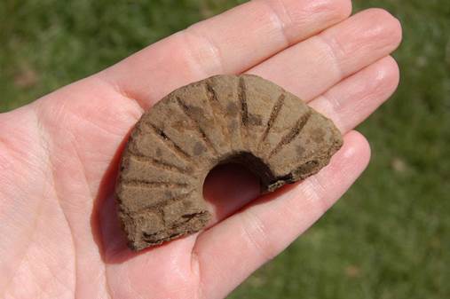
Piece of a decorated spindlewhorl found during the 2015 excavation.
In the final phase of occupation, main phase 8, the previous roundhouse was removed almost completely and replaced by another one in almost the same spot. Since of this roundhouse, almost all of the lowest one or two rungs of the inner drystone facing of its wall survived, it was possible to establish that its entrance was facing in a south-easterly direction, going through and digging out what may have remained of the northern inner bank terminal at this time.
Whether the outer bank was still substantially upstanding at this time, or had already been as badly eroded away as the inner bank, could not be determined. Thus, it is quite possible that throughout much of the later phases of occupation at Meillionydd, the settlement was only enclosed by a single bank (the outer one) with a simple gap as the entrance, with the inner bank still partially visible, but slowly eroding away. It may even be that throughout much of phases 4-7, while both banks certainly will still have been visible to some extent, they were no longer properly maintained, thus ever so slowly turning Meillionydd into an ‘open’ (more or less unenclosed) settlement again.
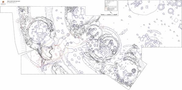
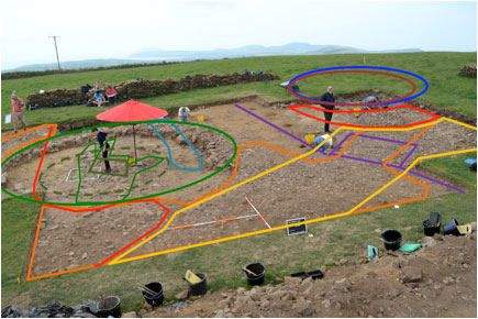
Plan of trenches 1-6 (image: R. Karl).
At the end of their respective occupation, many stone-built roundhouses (regardless of what particular phase they belonged to) also seem to have been intentionally backfilled with smaller stones, many of them heat-affected, resulting in a sometimes very loose, stony infill. Sometimes, there is so little earth between these stones that sizeable gaps (air-pockets) exist in these infills.
Yet, these infills contain surprisingly few finds of any kind, making it unlikely that abandoned roundhouses were backfilled with ordinary settlement rubbish. Rather, this seems to have been a specific ‘closure rite’ that was observed whenever a house was abandoned and/or replaced by another. Interestingly, this backfilling process is also observable in the final phase (phase 8) roundhouse in the inner entrance area. This indicates that either occupation of the site continued until after the abandonment of the last house, even if only in other parts of the site, or that this ‘closure rite’ also took place when the site was finally abandoned completely.
Plans for the 2016 excavations (Season 7)
In 2016 a 20x15 meter trench will be opened north-west to former trench 6 to further examine the inside of the enclosure. It should cover a heavily built-up area on the north-western side of the enclosure and allow us to partially excavate the largest roundhouse on site.